|

|
China’s `Space Silk Road:’ To Scout Infrastructure From Space

2 June 2015
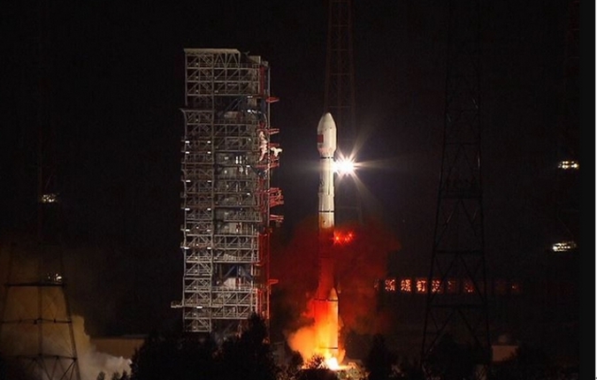
EIRNS—On March 31, 2015, China successfully launched the Long March 3 (LM-3) orbital carrier rocket, carrying the first of China’s new generation Beidou satellites, set to transform the Beidou satellite navigation system from a regional to an international guidance system. The next day, April 1, Global Times reported that Deputy Director General of China Satellite Global Services Alliance (CSGSA) Wang Zhongguo, annnounced the latest stage in the construction of a "Space-Based New Silk Road," at a press conference in Beijing . Wang stated that the new generation Beidou satellites will enable the smooth development of China’s "One Belt, One Road" project— the Silk Road Economic Belt and the 21st Century Maritime Silk Road. Local Chinese authorities along the "Belt and Road" routes discussed their participation in that project, at the Second China International Satellite Service Business Matching Event held May 29 in China. Global Times reported on May 31, that Deputy Mayor Wang Jiubin of Yinchuan, capital of northwest China’s Ningxia Hui Autonomous Region, spoke there about the China-Arab satellite data service industrial park in his city, which will be a key platform for China to offer data services to Arab countries and regions. "China’s satellite technology, which offers high quality and low costs, can meet demand in the Arab world," Wang said. A top engineer from the Xinjiang Satellite Application Engineering Centre argued that his Xinjiang Uyghur In March, Wang had said CSGSA has established trial satellite receiving bases in Xinjiang, Ningxia, Hainan, and Fujian, all important locations for the Belt and Road projects. After this it will move westwards over land, through Central Asia and Southwest Asia to Europe and over sea through the South China Sea, the Pacific, the Indian Ocean to Africa and South and Central America. He reported that the CSGSA has entered into talks with a range of countries, including Malta, Malaysia, India, the United States and Norway regarding establishing satellite receiving facilities within their borders. The "Space Silk Road" is also key to improving communications infrastructure with the Shanghai Cooperation Organization countries, Wang said. He reported that China has proposed using joint SCO funds to implement the navigation system, as well as communications and Earth remote-sensing capabilities, for land and the oceans. Data from remote-sensing and navigation satellites will be used to lay out routes, describe the geography, inventory resources, locate the effects of natural disasters, and for many other functions. Wang described the "Space Silk Road" as a "scout for infrastructure construction along the land and sea routes." Besides helping Chinese businesses to expand internationally and recording ongoing development of infrastructure construction included in the Belt and Road project, the space-based Silk Road will enable the Chinese government to continue observing different regions of the world, including in the event of a natural disaster or other unforeseen circumstances. Ramtanu Maitra and Marcia Freeman |